Soils are a porous media which consist of solid particles, water and air. Water in soils is generally liquid except in Arctic soils where it is mostly frozen. This particularity of Arctic soils arises from their exposure to the extremely cold atmosphere in winter, resulting in extensive soil cooling and soil temperatures below 0°C. When soils are frozen for two consecutive years, they are called permafrost, which is the type of soil that is found in most parts of the Arctic. On Bylot Island, a weather station close to our main field station measures soil temperature profiles since 2000 and the acquired data allow us to study the specific thermal profile of the Qarlikturvik Valley soil.
Differences in winter and summer soil temperatures

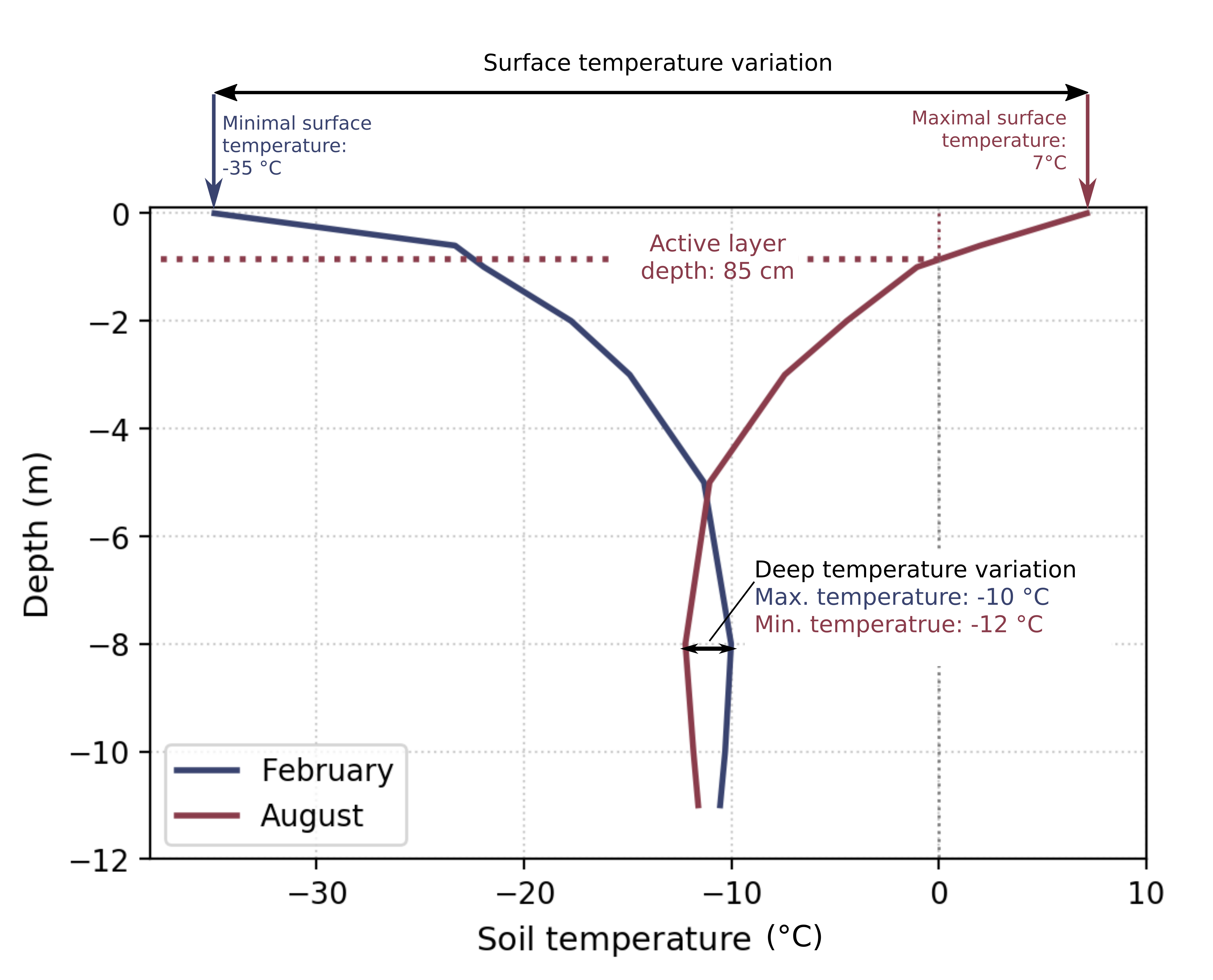
In the summer (August) profile temperatures at the soil surface are 7°C whereas in winter (February) surface temperatures drop to -35°C showing the extreme temperature variations happening at the soil surface. Those large variations are caused through the direct contact of the soil surface with the atmosphere, which itself undergoes extreme temperature changes over the seasons (see Arctic climate). In deeper layers the influence of atmospheric temperatures is weaker and the difference between summer and winter temperatures decreases. For example, the temperatures measured at the weather station close to our field station at a depth of 8 m varied only between -10°C and -12°C. Therefore, soil thawing happens only close to the surface where soils get heated enough in summer for their temperatures to rise above 0°C. In deeper layers soil temperatures are constantly below 0°C and soils remain frozen throughout the year. The surface layer which undergoes freezing and thawing over the seasons is called ‘active layer’ and its thickness can vary a lot depending on how cold winter and how warm summer air temperatures are. The active layer of the soil near our main field station on Bylot Island is 8.5 cm thick.
An interesting feature in deeper layers is that winter soil temperatures are warmer than summer soil temperatures. The reason for this reversed temperature pattern is that heat needs time to travel through the soil. The relatively colder summer temperatures correspond thus to the cold signal of the previous winter which reaches the deeper layers only during the summer months. Vice versa, the relatively warmer winter temperatures correspond to the heat of the previous summer which is still traversing the soil. This effect of heat traveling like a wave through the soil becomes clearer when looking at the monthly evolution of the soil temperature profiles (see below).
Monthly soil temperature profiles
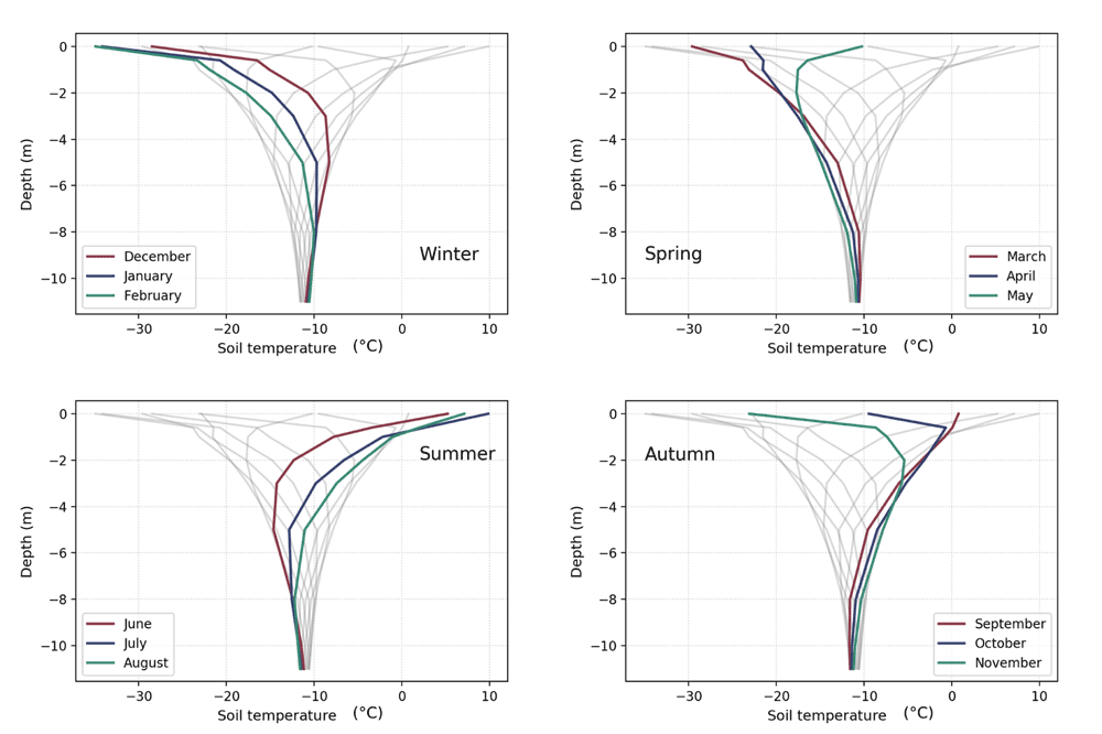
Considering the temperature profiles for each month allows to observe how the cold of the winter months and the warmth of the summer months are slowly transmitted from the soil surface towards deeper layers. During the three winter months, the soil surface is cooled down by the cold atmosphere and soil surface temperatures in the winter profiles are low, reaching their coldest value in February. In spring, the atmosphere starts to heat up, warming also the soil surface and the soil surface temperatures in the temperature profiles start to rise compared to the winter values. In deeper layers, however, soil temperature keeps decreasing in the spring profiles, showing the progression of the cold signal of the previous winter months. In summer, the atmosphere reaches its warmest temperatures, also heating up the soil surface and resulting in high soil surface temperatures in the profiles with the warmest values in July. In contrast, in the deeper layers soil temperatures reach their minimal value due to the cooling influence of the progressing cold signal of the previous winter months. In autumn, the atmosphere starts to cool down again, decreasing also the soil surface temperatures while in the deeper layers soil temperatures start to rise as the summer warmth starts moving through the soil. Back in winter, the summer warmth heated the deeper layers which now reach their maximum values. The slow progression of the summer warmth and winter cold result thus in summer and winter soil temperature profiles that are the opposite of each other: summer profiles have the warmest surface and coldest deep layer temperatures while winter profiles have the coldest surface and warmest deep layer temperatures.
 |
| For each season, the monthly soil temperature profiles are highlighted in color, while the profiles of the remaining three seasons are shown in light gray. Data are from Allard et al., 2020 (doi: 10.5885/45291SL-34F28A9491014AFD). |
A closer look at soil surface temperatures in autumn

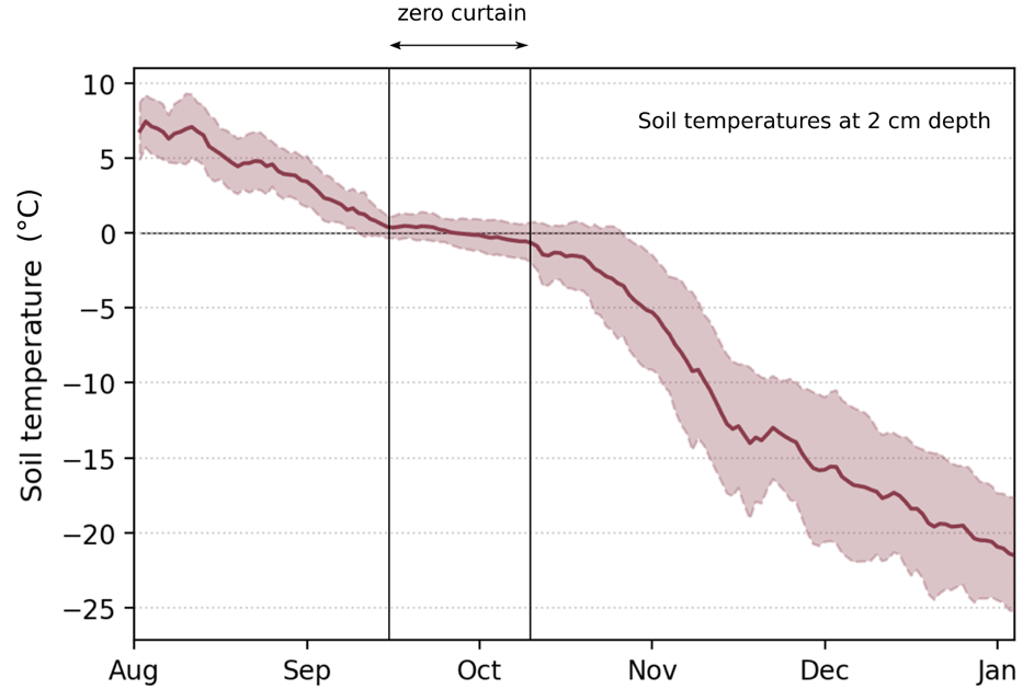
In autumn, most Arctic soil temperature data measured at the surface exhibit a plateau because soil temperatures remain constant at 0°C over an extended period of time. This plateau is referred to as the ‘zero-curtain effect’. Observing this effect is surprising because at the same time as soil temperatures exhibit the zero-curtain effect, air temperatures keep dropping significantly below 0°C (see Arctic climate) and it would be expected that soil temperatures would decrease simultaneously with air temperatures. The zero-curtain effect is created by water in the soil, which is liquid in the active layer after summer, but which starts freezing once temperatures in the soil reach 0°C in autumn. Soil temperatures stay at 0°C until the water phase change is completed and all water in the soil is frozen, thus creating the zero-curtain effect. The length of the period of zero curtain depends on the water content in soils at the end of summer, with a larger amount of water causing a longer period of zero curtain. The zero-curtain effect is a key feature for the Arctic flora and fauna as it keeps the soil relatively warm in autumn when the air is already very cold and it is equally crucial for the evolution of the snowpack and its snow physical properties like snow grain size and snow density, which in turn are important for the survival of the Arctic flora and fauna in winter.
| Arctic climate | Long-term climate observations |
