Bylot Island is located off the northern tip of Baffin Island, Nunavut, Canada. The nearest community from which Bylot Island can be accessed is Pond Inlet (Mittimatalik) on northern Baffin Island. Established in 2001, Sirmilik National Park encompasses most of Bylot Island, except for a few pockets that are Inuit-owned lands. Covering an area of 22,000 km², this park extends to the northern part of Baffin Island and is one of the largest national parks in Canada. Sirmilik, which means “place of the glaciers” in Inuktitut, certainly reflects the complex of glaciers and ice caps that cover most of Bylot Island. Much of the 11,100 km² of Bylot Island is covered by high mountain peaks and glaciers. These are the Byam Martin Mountains, which form a part of the larger Arctic Cordillera extending from the eastern margin of Baffin Island all the way to Ellesmere Island. The remainder of Bylot Island, and in particular its southern plain, are characterized by extensive low-elevation areas covered by heterogeneous tundra vegetation.
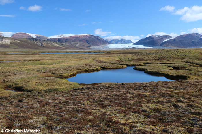
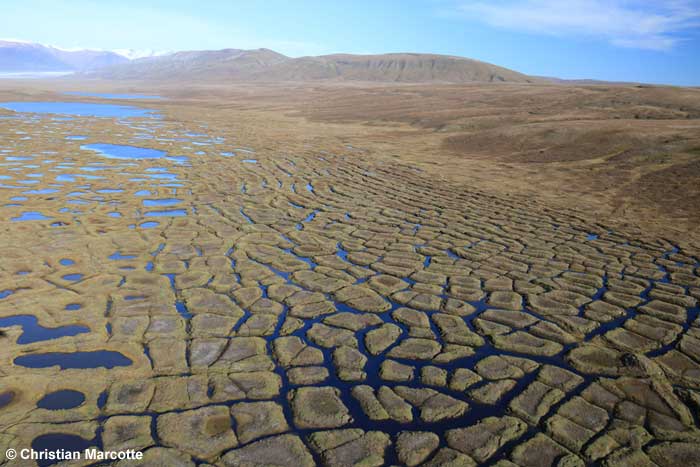
Although our field research covers the south plain of the island (1,600 km²), our main field station is located in a large glacial valley at the southwest end of the island (73°08’N, 80°00’W). About 10,000 years ago, this 70 km² valley, called Qarlikturvik, was almost entirely covered with ice. Approximately 6,000 years ago the glacier started to retreat, leaving fine grained wind-deposits and an accumulation of organic sediments to form the soils in the valley bottom. Meanwhile, freeze-thaw action worked in shaping the land to its present form. Today, the valley bottom consists of an assemblage of tundra polygons, thaw lakes and ponds. The water retaining capacity of these topographical features and the poor drainage of the underlying layer of soil that is permanently frozen (permafrost) contribute to the formation of wetlands. The vegetation found in these wetlands is characterized by the presence of sedges, grasses and many moss species. In contrast with the wetlands, dryer areas are found on slopes, hills and elevated terraces surrounding the valley lowlands, as well as on the rims surrounding tundra polygons. The better drained, dryer soils of these habitats allows for distinct plant communities. Common plants found in this habitat include forbs, grasses and shrubs. These areas commonly referred to as uplands, account for 90% of the south plain surface whereas wetlands account for only 10% of it.

|

|
|
| Qarlikturvik Valley | Tundra polygons, thaw lakes and ponds |
The wetlands of the south plain of Bylot Island is a habitat of rare plant quality and productivity for an Arctic environment. Benefiting from this “polar oasis” are >160 species of plants, >15 mammal species and >70 bird species. Considered as an important site for many migratory birds, Bylot Island was declared a Migratory Bird Sanctuary in 1965. Amongst the migratory species taking advantage of the lush wetland vegetation, the greater snow geese first caught the attention of the project leaders in the late 1980’s. Indeed, the south plain of Bylot Island holds one of the world’s largest breeding colonies of greater snow geese and the wetlands of the Qarlikturvik Valley represent their main brood-rearing site on the island. With more than 100,000 birds passing the summer on Bylot, it is clear that geese constitute the most abundant herbivores of the island. In addition to the greater snow goose, other herbivores found on the island are the brown and collared lemmings, the cackling goose, the arctic hare, and the rock ptarmigan. The main terrestrial predators on the island are the arctic fox, the long-tailed jaeger, the parasitic jaeger, the glaucous gull, the common raven, the rough-legged hawk and the snowy owl.
| A look back |
